Tuesday, May 13, 2008
Thursday, April 3, 2008
Lab 10 - Google Earth Map Overlays
This was a pretty easy lab. I kind of enjoyed it actually. Here's a tip though...make sure you use good quality maps. I fooled around with 2 or 3 that didn't work too well before I used these. Here is my .kmz file...
http://rkpalmerjr.googlepages.com/Lab_10_MapOverlays.kmz
Mt. Vernon Trail and Fountainhead Regional Park...

Mt. Vernon trail along the George Washington National Parkway...
.jpg)
Fountainhead Regional Park Mountain Bike Trails...
.jpg)
No more labs!!! On to the final projects...woohoo!!!
http://rkpalmerjr.googlepages.com/Lab_10_MapOverlays.kmz
Mt. Vernon Trail and Fountainhead Regional Park...

Mt. Vernon trail along the George Washington National Parkway...
.jpg)
Fountainhead Regional Park Mountain Bike Trails...
.jpg)
No more labs!!! On to the final projects...woohoo!!!
Tuesday, April 1, 2008
Map of Ludacris' Hoes
I came across this map on the strangemaps blog and thought it was too funny. I had to post it on my blog. Those of you who know the song will get it.

Here's what is said at strangemaps.wordpress.com...
"“I’m a female and a feminist. I dislike the usage of the word ‘ho’. However, as a geography major, I find this song hilarious, and had to map it,” says Stefanie Gray, referring to ‘Area Codes’ by the rap artist Ludacris.
Rap, for those less familiar with the term, is a genre in which the rhythmic delivery of rhyme and wordplay constitutes the main element of the music. Rap relates to singing as racewalking relates to running – but that’s just my inexpert opinion.
Rap music has been criticised for its content, which often consists of crude and ludicrous bragging about the rapper’s lyrical, financial, criminal, physical and sexual prowess. ‘Area Codes’ could be considered as an example of this phenomenon, sometimes referred to as gangsta rap:
“I’ll jump off the G4, we can meet outside/So control your hormones and keep your drawers on/’Til I close the door and I’m jumping your bones/3-1-2’s, 3-1-3’s (oh), 2-1-5’s, 8-0-three’s (oh)/Read your horoscope and eat some horderves (sic)/Ten on pump one, these hoes is self serve/7-5-7, 4-1-0’s, my cell phone just overloads.”
“In this song, Ludacris brags about the area codes where he knows women, whom he refers to as ‘hoes’,” says Ms Gray, who plotted out all the area codes mentioned in this song on a map of the United States. She arrived at some interesting conclusions as to the locations of this rapper’s preferred female companionship:
* “Ludacris heavily favors the East Coast to the West, save for Seattle, San Francisco, Sacramento, and Las Vegas.”
* “Ludacris travels frequently along the Boswash corridor.”
* “There is a ‘ho belt‘ phenomenon nearly synonymous with the ‘Bible Belt’.”
* “Ludacris has hoes in the entire state of Maryland.”
* “Ludacris has a disproportionate ho-zone in rural Nebraska. He might favor white women as much as he does black women, or perhaps, girls who farm.”
* “Ludacris’s ideal ‘ho-highway’ would be I-95.”
* “Ludacris has hoes in the Midway and Wake Islands. Only scientists are allowed to inhabit the Midway Islands, and only military personnel may inhabit the Wake Islands. Draw your own conclusion.”
Ludacris is not deterred by clever and/or strong women? The concept of Ludacris’ song reminds me a bit of ‘I’ve Been Everywhere’ by Johnny Cash, which, come to think of it, probably shares some subtext with ‘Area Codes’.
Map kindly provided by Stefanie Gray."
This post is at http://strangemaps.wordpress.com/2008/03/09/254-ludacris-rap-map-of-us-area-codes/
Friday, March 28, 2008
Lab 9 - Google Earth and Sketchup Cont...
Here's the link to my .kmz file. (This Google Pages stuff is awesome by the way)
http://rkpalmerjr.googlepages.com/Lab9_GMU_3D_RKPJr.kmz
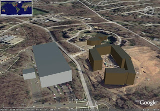
It figures I would get stuck with buildings that did not exist when this satellite image was taken. Only one of these buildings were completed at the time. Sandy Creek Parking Deck is placed over a bunch of cars right now. I think the buildings actually look much better in the image from Sketchup.

.jpg)
.jpg)
.jpg)
http://rkpalmerjr.googlepages.com/Lab9_GMU_3D_RKPJr.kmz
It figures I would get stuck with buildings that did not exist when this satellite image was taken. Only one of these buildings were completed at the time. Sandy Creek Parking Deck is placed over a bunch of cars right now. I think the buildings actually look much better in the image from Sketchup.

.jpg)
.jpg)
.jpg)
Thursday, March 27, 2008
Map post...
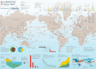
I chose a map that wasn't actually displayed on that website, but that I found through a link from one that was. This one shows submarine cables going across major bodies of water. One of the things I really like about this map is the diagram and charts and mini map along the bottom. The diagram and the chart that shows submarine cable capacity on the bottom corners are especially interesting I thought, and really add to the entire map.

Lab 8 - Google Earth and Sketch Up
Here is the first part of Lab 8 - my Google Earth file.
http://rkpalmerjr.googlepages.com/Lab8Placemarks.kmz
Also here is my "geography tool of the future." Ummm, I guess its a 3D image table thing. Kind of like what they used to plan out the attack on Death Star in Star Wars. Wow...I'm a dork. Anyway, this one is looking at a city.

http://rkpalmerjr.googlepages.com/Lab8Placemarks.kmz
Also here is my "geography tool of the future." Ummm, I guess its a 3D image table thing. Kind of like what they used to plan out the attack on Death Star in Star Wars. Wow...I'm a dork. Anyway, this one is looking at a city.

Monday, March 10, 2008
Lab 7 - Shape Tweening...
This shape tweening stuff is pretty difficult. For some reason the front line in the south gets all funky. I don't know. After July 16th though it works almost perfectly. I'm tired of messing with it though as I've wasted the past 2 or 3 hours trying to fix it without success. Maybe later...
Link...http://img90.imageshack.us/img90/7946/lab7qu6.swf
Link...http://img90.imageshack.us/img90/7946/lab7qu6.swf
Subscribe to:
Posts (Atom)